
A Coastal Perspective on Dam Removal
By Ian Miller, Huxley Class of 1996
This article was modified from a version that appeared in 2018 in the International Water Power and Dam Construction Journal

Elwha Dam Removal Photo credit: Kate Benkert (USFWS). Available at Flickr under a Creative Commons Attribution-NonCommercial 2.0
Inthe winter on the Elwha River delta the lowest tides occur at night, and I’m out there every month, walking the beach and making measurements. My time alone on the nighttime Elwha beach can be a bit spooky, depending on the thickness of the fog, or the brightness of the moon. I’ve been doing these monthly walks on the Elwha River delta, though, for the past 7 years, fighting through the spookiness to collect data on the shape and position of the shoreline and the grain size of the beach. I’m out here trying to figure out how the whole coastal system works.
I’m a coastal scientist, and my first love is shorelines; how they change and respond to waves, sea level and tides, and also how they shape the communities of plants and animals that call them home. Dam removal is a secondary interest, but the removal of two large dams on the Elwha river has afforded me the single best opportunity of my career to work at the cutting edge. The Elwha has become an ideal living laboratory for studying the nuanced functions of a large, natural coastal system.
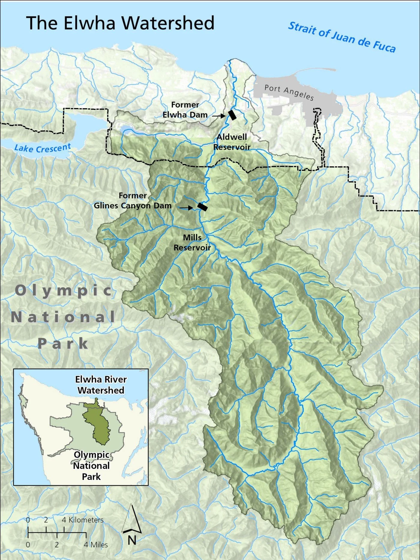
Overview map of the Elwha River watershed, and the former location of the Elwha and Glines Canyon dams. Map courtesy of Olympic National Park
The lowest of the two dams on the Elwha River blocked the river five miles from its mouth, and was completed in 1913. The dam was built largely due to the energy and motivation of one man, Thomas Aldwell, and the reservoir behind the dam carried his name. The uppermost Glines Canyon dam was completed in 1925 and spanned a narrow canyon 13 miles from the river mouth. Above this upper dam the watershed is wholly within the bounds of Olympic National Park, and filled with the sort of pristine river and side channel habitat that is rare in the contiguous United States.
The dams symbolized a social balancing act. A stroll around Port Angeles, where I live and raise my family, reveals numerous large buildings, bridges and other big infrastructure projects whose foundation stones are stamped with the year 1913. Its not a stretch to say that the dams on the Elwha River built my town.
These same dams also completely blocked the river in two places. Salmon, trout, lamprey and other fish that migrate up the river from the sea were limited to the lowest five miles of a 72-mile long river, and sediment and wood flushed from the watershed were trapped in its upper reaches. The dams also were part of the historic disruption of the lives of members of the Lower Elwha Klallam Tribe, who are culturally and economically tied to the river. The voices of the Lower Elwha Klallam were amongst the most persistent and passionate arguing for dam removal.
The removal of the two dams did not come easily. I moved to Port Angeles just two years after the U.S. Congress passed the Elwha Act in 1994. The act did not require dam removal, but rather specified the “full restoration of the Elwha watershed”. In retrospect the Elwha Act of 1994 sealed the fate of the dams, but at the time that wasn’t clear, and the passage of the act was followed by years of wrangling about how to carry out the wishes of congress. I had plenty of opportunity to observe the final years of the long, contentious dam removal debates and arguments that were kicked off in the mid 1970’s by a FERC re-licensing process. The decisions that were made were heart-wrenching business.
The Elwha has become an ideal living laboratory for studying the nuanced functions of a large, natural coastal system.
As the debate about the removal of the two dams in the early 2000’s started to transition from “if” to “when” and “how”, I started to spend a lot of time down at the mouth of the Elwha River on a surf board, chasing after the phantom swells that ghost in from the Pacific Ocean through the narrow Strait of Juan de Fuca. The beach of the Elwha River delta was rapidly eroding, and surfing provided a front row seat for a show put on by a complex and changing coast. People wondered if the chronic erosion on the beach was related to the construction of the dams, and the sediment they trapped in their reservoirs. As I pondered the question, I was hooked. That question set the trajectory of my scientific career, and formed the core of my dissertation research focused on coastal sediment transport, with the shoreline around the Elwha River mouth as my laboratory.
I was on the river when the first chunks of the two dams on the Elwha River were plucked out in September 2011. I was awarded a PhD just a few months after that and started a position with the Sea Grant program at the University of Washington. I was able to include an Elwha coastal monitoring program in my work plan. Two primary questions drove my work: First, how would the coastal environment physically respond to dam removal? The two reservoirs on the river held around 24 million cubic meters of mud, sand and gravel — enough sediment to fill a large sports stadium many times over — accumulated over a century. With the two dams out of the way the expectation was that much of this sediment would move from the river into the coastal environment. What would be the consequences of that? How would it shape the coast?
Second, how would the transfer of sediment into the coastal environment affect the suite of fish, invertebrates, seaweeds, birds and marine mammals that made their home in the Strait of Juan de Fuca near the mouth of the Elwha River? These investigations also gave me the opportunity to partner with a large group of other researchers studying everything from salmon, to bear, to birds, to vegetation. This group of researchers, collectively, were focused on trying to figure out how to best track and describe how the landscape and ecosystem responded to this massive watershed project. The Elwha Dam removal was unprecedented in its scale, so the various investigations also invariably advanced our understanding about how natural systems work. It was heady stuff for a young scientist.

While deposition on the sea-floor wasn’t widespread, small areas near the river mouth were transformed. These are photos of the same location on the sea-floor from before (Summer 2011) and after (Summer 2017) dam removal. A surveyor’s tape laid down by SCUBA divers runs through both photos. While the image in the lower panel looks lifeless relative to the earlier 2011 photo, these sandy patches were quickly utilized by new species.
After roughly 10 years of observing the dam removal through its various stages, and in particular its coastal effects, I am struck by three things. First, the river was amazingly efficient at moving sediment downstream during dam removal. The sediment trapped in the Elwha River reservoirs was eroded rapidly as the dams came down, and most of it moved to the coastal environment quickly. For example, as the upper dam was drawn down in November of 2012 a huge slug of sand and gravel was eroded from the reservoir and ended up on the beach, 13 miles distant, only a few weeks later. As of 2019 about 60% of the sediment trapped in the two reservoirs has been eroded. Nearly all of that made its way into the Strait of Juan de Fuca.
Next, once in the coastal environment, most of the mud in the eroded sediment disappeared. At least, we can’t find it. In retrospect this isn’t an enormous surprise. The receiving waters for the Elwha River, the Strait of Juan de Fuca, are energetic. There are few places in the Strait where water is still enough to allow mud to settle on the bottom. But it led to an interesting outcome of the dam removal from the standpoint of many of the coastal scientists working on the project: Despite the massive volume of sediment that reached the coast during the dam removal, only small areas of the sea-floor were affected. In other words, we can find deposition from the dam removal in only a few areas of the sea-floor near the river mouth.
The mud, though, that gushed from the river during dam removal, and moved through the coastal system, did lead to one of the more noticeable ecological impacts of the dam removal, which was that photosynthetic algae, what most of us know as seaweeds, were knocked back during dam removal throughout much of the coastal zone. Recent work by University of Washington graduate student Hannah Glover suggests strongly that this was simply due to a loss of light on the sea-floor from all of the mud floating in the light buoyant freshwater of the river plume, and spreading out like a cloud over the marine communities on the sea-floor below. The influence was short-lived though. As the dam removal concluded in 2015, and sediment concentrations in the river declined, the seaweeds bounced back.

While deposition on the sea-floor wasn’t widespread, small areas near the river mouth were transformed. These are photos of the same location on the sea-floor from before (Summer 2011) and after (Summer 2017) dam removal. A surveyor’s tape laid down by SCUBA divers runs through both photos. While the image in the lower panel looks lifeless relative to the earlier 2011 photo, these sandy patches were quickly utilized by new species.

The river mouth of the Elwha River was transformed by dam removal. While the mud that made it to the coastal zone has largely moved out of the system, much of the sand and gravel deposited right near the river mouth during dam removal, and is still there. It built new beaches, estuary lagoons, and other shallow coastal habitats. The sea-floor was also transformed in patches right near the river mouth. The dots reference locations of photos shown above.
Finally, where we can track and observe sediment that has deposited on the sea-floor or on the beach, the consequences of that deposition often have a very positive outcome socially and ecologically. For example, chronic erosion characterized the beach of the Elwha River delta prior to dam removal. At this point, erosion has stopped or reversed along shorelines as much as 5 miles from the river mouth. Another example; beneath the surface of the Strait of Juan de Fuca near the river mouth are patches of sea-floor that were transformed by sediment deposition. Formerly cobble areas are now sandy, and formerly sandy areas are now muddier. In places as much of 2 to 3 feet of sediment were layered on top of former sea-floor habitat.
On the face of it we might view such dramatic deposition as catastrophic for the marine ecosystem, but our data shows that in fact many organisms were resilient to the deposition. In some cases species even thrived. One of my favorites are Pacific Sand Lance, a tiny sliver of a fish, that are a favorite food of the salmon that seasonally course through Washington’s coastal waters. These little fish use sandy beaches and sea-floors for protection and spawning, and they quickly discovered these new sand patches after dam removal. Now, it wouldn’t be unusual for us to count hundreds of these fish on a single SCUBA dive in these new sandy habitats.
I think often of remarks made by Orville Campbell, a prominent mill manager in Port Angeles in the 1990’s. He was in the thick of the removal debates and led a local committee that eventually concluded that the removal of the Elwha dams was in the best economic interests of the local community. At the same time, though, Orville repeatedly emphasized that the decision to remove the dams was not an acknowledgement that those that decided to build them had made poor decisions, and most certainly didn’t deserve to be vilified.
I am very cognizant of the benefits dams provide me and my family. Indeed, my town still derives most of its electricity from the great dams on the Columbia River. The positive outcomes of the removal of the two dams on the Elwha River, though, provide new insights that help us as a society to more thoughtfully weigh the benefits of dams against the costs of keeping them in place. In many ways I see the lessons we’ve learned from the removal of the two Elwha River dams as fitting squarely in the tradition of Thomas Aldwell. He wanted to build the dams on the Elwha River to improve his community, and my research is illustrating the ways in which their removal can do the same.

About the Author
Ian Miller is an alumni of Huxley College of the Environment, graduating in 1996 with an Environmental Science degree, emphasis in marine ecology. He subsequently went on to earn a PhD in Ocean Sciences from the University of California, Santa Cruz. Ian is currently Washington Sea Grant’s coastal hazards specialist, and is also part-time faculty at Peninsula College in Port Angeles. He is an author on 16 publications focused on the Elwha dam removal. Before joining Washington Sea Grant, Ian served as the education director of the Olympic Park Institute and as Washington field coordinator for the nonprofit Surfrider Foundation.